Tunnel Under Scranton?
In an 1877 Scranton city atlas, I spotted a reference to a tunnel that I never knew existed!
December 2018
Our public library has a few old copies of an 1877 Scranton city atlas. One was falling apart, so they decided to frame and sell individual pages as a small fundraiser. My friend Elaine had purchased one as a gift for her daughter, and she asked for my help to go pick it up and deliver it to her house (those framed pages are big and heavy!)
I happened to see a TUNNEL marked on one of the pages. This was news to me! I’m pretty well versed in our local maps and the old railroads and I have never seen or heard anything about this supposed tunnel before. It appears to have passed right beneath the Rose Garden on campus where I read, eat lunch, and sometimes work in the summer.
Below is the relevant section of the map. Tunnel entrances are marked with the blue and pink arrows. I just can’t imagine what this could have been used for … big mystery!
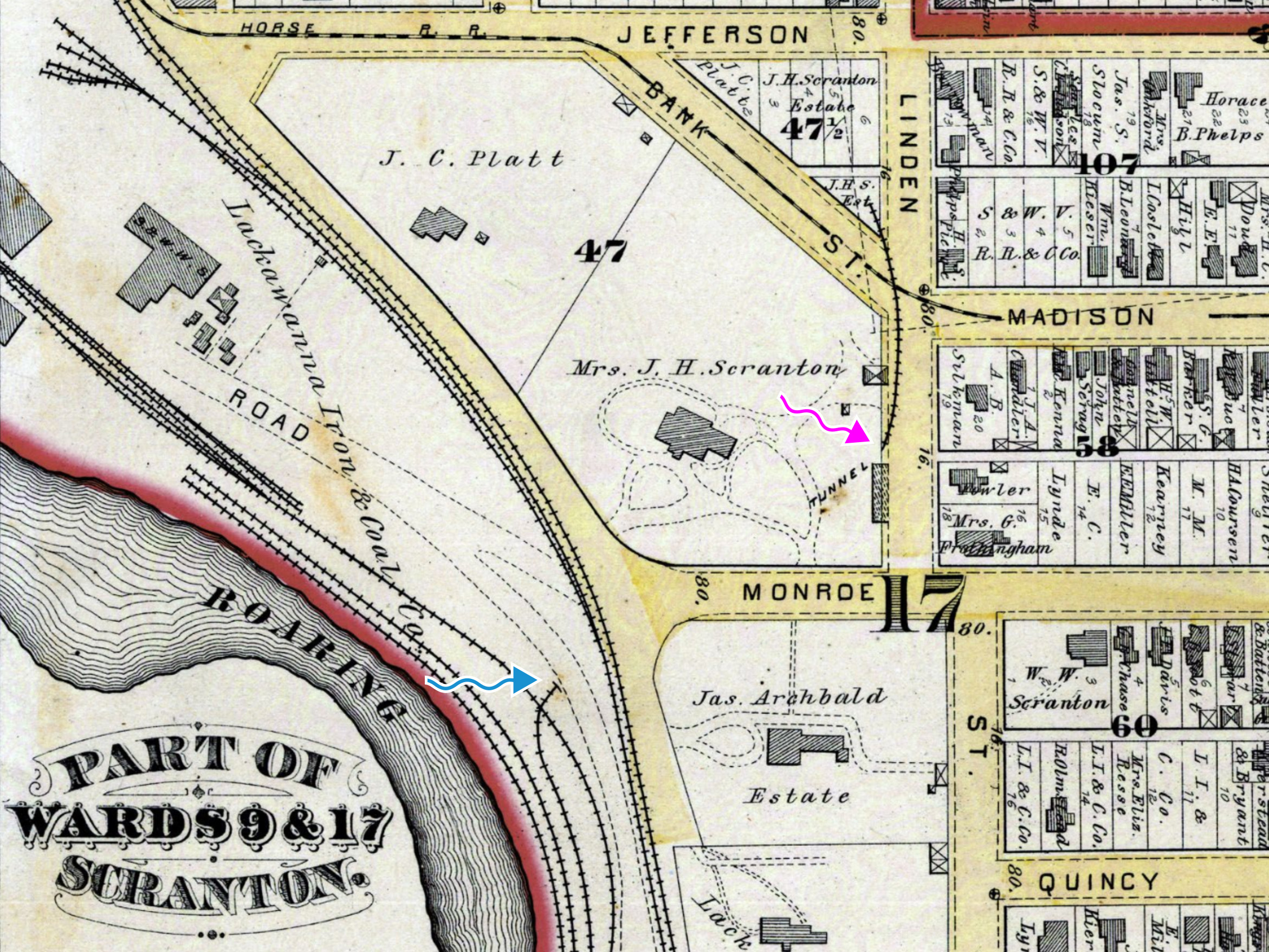
(Also see: Map of Wards 9 & 17, Scranton from the University’s Digital Collections; the complete map plate helps to put the tunnel’s location in context.)
A field trip to what I had determined to be the southern portal location yielded nothing much. I know there’s nothing at the northern entrance location.

January 2019
A few weeks later, I finally found a textual reference to the mysterious Scranton tunnel. Apparently the downtown area near the courthouse was literally a swamp in the mid-1800s, and the tunnel was used to bring cinders and refuse from an old iron rolling mill to fill in the swamp.
Two well-known features of the city topography have disappeared. Reference is made to the “lily pond” or swamp in the centre of Scranton, surrounded by Spruce street, Wyoming avenue, Linden street and Adams avenue, and the rock which reared itself some twelve or fifteen feet at the intersection of Jefferson and Lackawanna avenues and Ridge row. Adams avenue was graded across the swamp early in the summer of 1857 and was then first passable there. In January, 1858, the work of grading Washington avenue across the swamp was begun. A large portion of the swamp has since been graded up to a level with the surrounding land, by the use of ashes and other refuse from the iron rolling-mill, conveyed to the locality by a tunnel cut through a vein of coal for that purpose, which terminated at the corner of Bank and Linden streets, and which, having served its purpose, is now (1880) being closed.
From History of Scranton and Its People, Volume 1 (1914), p. 138
Topographical Changes in the City
The most important and striking of these, is the filling in and obliteration of the swamp, or “Lilly Pond” as it was popularly known. This was commenced early in the 50’s. For this purpose the Lackawanna Iron & Coal Company ran a tunnel through their mine gangway which entered the mine from the Nay-Aug gorge at the corner of Monroe avenue and Ridge Row, running it out at the corner of Linden and Bank (now Madison avenue) streets. Through this tunnel they ran a track from the mill above where the Laurel Line Power Plant now stands. Over this track a small locomotive daily took many carloads of cinders and ashes, which were dumped into the swamp. This was continued steadily until the aria_[sic]_ between Adams avenue and Bank street had been reclaimed, when Adams avenue from Spruce to Linden was graded and opened in 1857.